How to Read a Fish Finder: Depth, Bottom, Arches and the Line That Says Whether the Anchor Will Hold
Most people read a fish finder the way they read a photograph: a picture of the water under the boat, with the bottom at the bottom and the fish in between. It is not a photograph. It is a strip chart of echoes, drawn one column at a time, in which the only thing under the boat right now is the right-hand edge, the colours mean less than the thickness of the lines, and the number in the corner is measured from a plastic lump whose height above the keel the unit does not know unless you tell it. Learn those three things and the screen stops being a cartoon and becomes the most honest instrument on the boat. This guide goes through the screen from the edges in, the bottom types and what each looks like, the fish and the things that are not fish, the frequencies, the settings that matter, and the two minutes with the sounder that decide whether an anchorage is a good night or a bad one.
The short answer
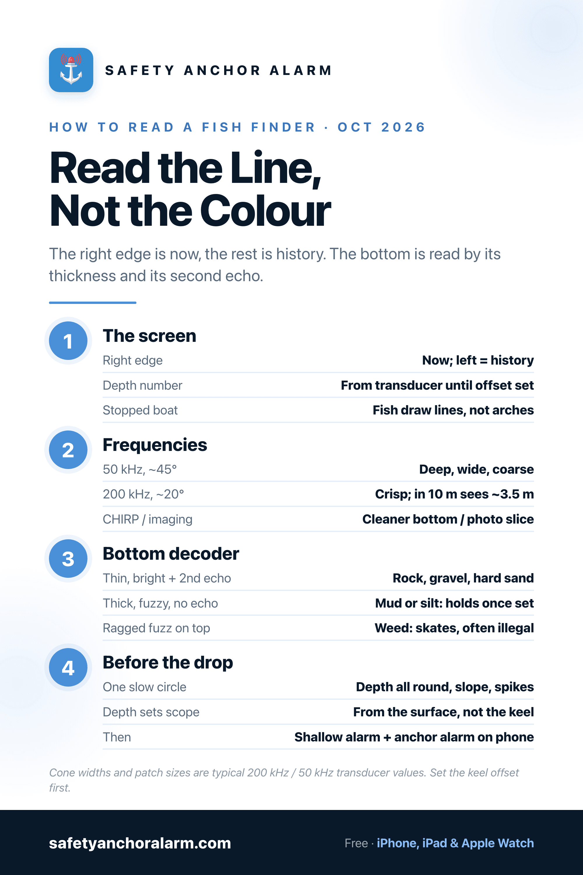
The screen scrolls right to left: the right edge is now, everything else is history. The big number is depth from the transducer until you set a keel offset. The bottom is the strong line across the screen; read its thickness, not its colour. A thin, bright line with a faint second echo at twice the depth is hard bottom (rock, gravel, packed sand); a thick, fuzzy band with no second echo is mud; a ragged fuzz sitting on top of the line is weed. Fish passing through the cone draw arches; a fish under a stopped boat draws a line; clouds are bait; a faint horizontal band mid-water is a thermocline. 200 kHz gives the crisp coastal picture, 50 kHz the deep wide one, CHIRP a cleaner version of either. Before anchoring, motor one slow circle over the spot with the sounder full screen: it shows the depth that sets your scope and the bottom that decides whether the anchor holds. It cannot tell you whether the anchor is holding once it is down; that is a GPS question.
The Bottom Decoder
What each seabed looks like on a 200 kHz or CHIRP trace at normal sensitivity, and what it means for the anchor. The second echo is the fainter copy of the bottom at exactly twice the depth; it only appears when the bottom is hard enough to bounce the ping back up to the hull and down again.
| Bottom | Bottom line | Second echo | Above the line | For the anchor |
|---|---|---|---|---|
| Sand (packed) | Thin to medium, bright, crisp edge | Usually visible, moderate | Clean water right down to the line | Best holding for most anchors; fluke and scoop types dig fast |
| Mud / silt | Thick, fuzzy, dim; depth number may flicker | None or very faint | Clean, sometimes a soft haze at the line | Holds well once set, slow to bite; let it soak, then load it gently |
| Rock / hard pan | Thin, very bright, jagged profile | Strong, sometimes a third | Clean; peaks and sudden steps | Poor holding; anchor snags rather than digs. Avoid or use a trip line |
| Gravel / shell | Bright and thin but even | Clear | Clean | Fair; anchor may skate before it catches. Back down hard to test |
| Weed / Posidonia | Dim true bottom under a ragged layer | Weak | Irregular fuzz 0.3–1 m thick sitting on the bottom | Anchor skates on the mat; protected and often illegal in the Mediterranean. Find a sand patch |
| Coral | Bright, lumpy, with steep steps | Strong | Clean, with isolated heads rising from the line | Do not anchor; damage and chain snags. Use a mooring or sand well clear of heads |
What the Screen Actually Is
A fish finder is a depth sounder with a memory. The transducer under the hull sends a pulse of sound straight down several times a second, listens for everything that comes back, and the unit draws the strength of each echo against the time it took to return, which is depth. One ping makes one thin vertical column: dark where nothing echoed, bright where something did. The unit paints that column at the right-hand edge of the screen, shifts everything already there one step left, and does it again.
So the screen is a strip chart, not a window. The right edge is the only part that is under the boat now. Everything to the left is where you were, in the order you were there. Three things follow from this that confuse every beginner. If the boat is stopped, the screen keeps scrolling and the same patch of water is drawn over and over, so a rock looks like a ridge and a fish holding under you looks like a flat line. If you go faster, the same bottom is drawn in fewer columns and looks steeper than it is. And the scroll speed setting changes how stretched the picture looks without changing anything in the water.
Four fixed things sit round the trace. The depth number, large, usually top left, is the distance from the transducer to the bottom. The range scale down the side tells you what depth each line of the screen represents; on auto range the unit keeps the bottom in the lower third, so the scale changes as you move. The surface clutter is a band of noise at the top, from bubbles, the hull and the first metre of water where the transducer cannot hear anything yet. And many units show an A-scope (Humminbird calls it the RTS window), a live vertical bar at the far right showing the current ping as it happens, which is the one part of the screen that really is a picture of now.
The Depth Number and Where It Is Measured From
The number everybody trusts is the one most often wrong, by a known amount nobody has entered. The transducer sits somewhere on the hull: on the transom just below the waterline on an outboard boat, through the hull a metre or more above the keel on a sailboat. The unit measures from there. It does not know how much water is above it or how much keel is below it until you set the keel offset (Garmin and Lowrance use that name; Humminbird calls it depth offset). Enter the distance to the bottom of the keel and the number becomes water under the keel; enter the distance up to the waterline and it becomes true water depth. On Garmin units a negative offset gives depth from the keel and a positive one from the surface; other brands word it differently, and the manual is the only safe source.
Which one you choose matters more than people think. For not running aground you want depth under the keel, because the only number that matters is how much is left. For anchoring you want true depth, because scope is calculated from the surface, plus the height of the bow roller above it, and a boat that reads 4 m under a 2 m keel is in 6 m of water and needs 30 m of rode at 5:1, not 20. Choose one, label the display, and do the arithmetic for the other. None of this is the tide: a sounder reads the water you are in now, and tonight's low water is the depth number minus the fall still to come, which is a tide table question and not a sonar one. The chart, for its part, shows soundings reduced to chart datum, which is a third number again.
Reading the Bottom: Thickness, Not Colour
The bottom is the strong, continuous line that runs across the whole screen, and it is the thing the sounder reads best. Colour palettes vary by brand and by the mood of whoever set them up, so the colour of the line tells you little. Its thickness and brightness tell you what the bottom is made of, and so does what appears below it.
A hard bottom (rock, hard pan, gravel, packed sand) reflects almost the whole ping. The line is thin, sharp and bright, and because so much energy came back up, some of it bounces off the hull and the surface, goes down again and returns a second time. That draws a second echo: a fainter copy of the bottom at exactly twice the depth, which is why it sometimes appears on the screen as if there were a second seabed far below. A strong second echo is the single most reliable sign of a hard bottom, and on rock there is sometimes a third.
A soft bottom (mud, silt, loose fine sand) absorbs the ping. The line is thick, fuzzy and dim, with a soft edge where the sound sank into the mud before coming back, and there is no second echo because there was not enough energy left for one. Very soft mud can confuse the depth reading, which flickers between the top of the ooze and the firm ground below it. Weed draws a ragged layer sitting on top of a dimmer true bottom, anything from a few centimetres of fuzz to a metre of jagged growth in a Mediterranean Posidonia meadow, and the depth number may read the top of the weed. Slope is simply the line climbing or falling as you move, read against your speed; a sudden step is a ledge or a rock, and a smooth gradient is a shelving beach.
Side imaging and down imaging make this easier still. Their high-frequency fan draws the bottom like a photograph taken from above, and sand, weed patches, rock and the odd mooring block are visible as textures rather than as a line to interpret. The combo guide explains which transducers include it; for a boat that anchors every night it is the one fishing feature worth paying for.
Fish, and Things That Are Not Fish
A fish is a single small target, and the sounder draws the distance to it on every ping. As the boat approaches, passes over and leaves it, that distance shrinks and grows again, so the plotted points form an arch. A full, symmetrical arch means the fish passed through the centre of the cone; a half arch, or a short tick, means it was on the edge. The size of the arch is mostly about how long the fish was in the cone, so a slow boat draws long arches from small fish; the thickness and brightness of the arch say more about the size of the fish than its length does.
If the boat is stopped, or the fish is swimming with it, there is no arch: the distance does not change and the fish draws a straight line. This is what drift fishers and anchored boats see, and it is why the ice-fishing flasher shows a dot rather than a trace. Bait appears as a cloud or ball, loose at the edges, often with larger arches below it. A faint horizontal band in mid-water that runs across the whole screen is a thermocline, the layer where warm water sits on cold, common in lakes and some Mediterranean bays in summer. Fish symbols, the little fish icons with depths beside them (Garmin fish symbols, Lowrance Fish ID, Humminbird Fish ID+), are the unit guessing at those same returns and are wrong often enough that most people who fish seriously switch them off and read the arches.
Two more shapes mislead. Interference, from another boat's sounder, your own engine or a badly earthed pump, draws regular speckle or diagonal lines across the whole water column. And a wake or prop wash under the transducer draws a dense band from the surface downward that can hide everything; if the screen goes white when you reverse, that is why.
Frequency, Cone and What the Sounder Can See
A transducer does not see straight down; it sees a cone, and the width of the cone is set by the frequency. The sounder reports whatever is nearest within that cone, which is why a rock on the edge of the cone shows as a bump in the bottom at the wrong depth.
| Band | Cone | Patch seen | What it shows | Use it for |
|---|---|---|---|---|
| 50 kHz (low) | ~45° | In 10 m: ~8 m across | Deep water, wide coarse picture, weak detail | Offshore depth, finding a bank |
| 83 kHz / 77 kHz (medium) | ~50–60° | In 10 m: ~10 m across | Wide search cone in shallow water | Scanning for structure, counting bait |
| 200 kHz (high) | ~20° | In 10 m: ~3.5 m across | Crisp bottom, clear arches, to ~200 m | Coastal sailing, anchoring, most fishing |
| CHIRP (band sweep) | Depends on band | As the band | Separated targets, cleaner bottom, less noise | Default on any unit that has it |
| 455 / 800 kHz, 1.2 MHz (imaging) | Thin fan | A slice, not a cone | Photo-like bottom, side scan to ~60 m each side | Structure, wrecks, inspecting a bottom before you drop |
The practical reading of that table: at 200 kHz in 10 m of water the sounder is looking at a patch of seabed about the size of a dinner table, and in 5 m about the size of a cockpit. That is why one reading is not a survey, and why the anchoring check below is a circle and not a glance. CHIRP sweeps a band of frequencies in each ping rather than a single tone, which lets the unit tell two targets apart that a single-frequency ping would merge, and draws a thinner, cleaner bottom line; on any unit that has it, leave it on. The imaging frequencies trade reach for detail completely: a fan a few degrees thick that draws the bottom as a picture out to about 60 m each side in shallow water and loses the fish arches entirely.
The Five Settings Worth Touching
- Keel offset. Set it on day one, as above. Nothing else on the screen means anything until the depth does.
- Sensitivity or gain. How hard the unit listens. Auto is right in open water; raise it in deep water or soft mud until the bottom is solid, lower it in weed and shallows when the screen fills with speckle. The old rule still works: raise it until the water column fills with noise, then back off one step.
- Range. Auto keeps the bottom on screen and is right for passage making. Switch to manual and bottom lock or zoom when you want to inspect the last few metres above the seabed, which is where weed, rocks and the fish live.
- Fish symbols off. The unit's guess is worse than yours after a week of looking at arches.
- Shallow-water alarm. Every sounder has one. Set it to your draft plus a metre under way and it is the cheapest grounding insurance on the boat; at anchor it becomes a second alarm, as below.
Everything else, palettes, noise rejection, surface clarity, scroll speed, is cosmetic or situational. Palettes in particular are worth leaving alone, because the bottom reading above depends on learning how one palette shows a hard line and a soft one, and changing it resets your eye.
The Two Minutes Before the Anchor Goes Down
Here is where the sounder earns its place on a boat that never catches a fish. The anchoring guide says to choose the spot before you drop; the sounder is how. Pick the place you intend to lie, then motor one slow circle over it, roughly the size of the swing you expect, with the sounder on full screen at 200 kHz or CHIRP, bottom lock on if you have it, and read three things.
Depth, all the way round. The number at the drop point sets the scope; the numbers at the edges of the circle tell you whether the boat will swing into shallower water on a wind shift or hang over a drop-off, where the chain lifts the anchor and the boat's drag runs downhill towards deep water. A circle that reads 6 m on one side and 2 m on the other is a different anchorage from a flat 6 m, and the chart will not have told you.
The bottom, by its line. A thin, bright line with a second echo is hard; find the thick, dimmer line of sand or mud instead. A ragged fuzz above the bottom is weed, and in much of the Mediterranean that fuzz is Posidonia, which the anchor will skate across and which the Mediterranean anchoring rules increasingly prohibit anchoring in at all. The clean, slightly dimmer gap between two patches of fuzz is the sand you are looking for, and the sounder finds it in a way no amount of peering over the bow in 8 m of water can. Match the bottom to the anchor you carry: the sand, mud and rock anchor guide is the other half of this reading.
Obstructions. Isolated bright spikes rising from an otherwise clean line are rocks, coral heads or mooring blocks, and any of them will foul a chain in a wind shift. Note where they sit on your circle and lay the anchor so the swing clears them, or move.
That circle also gives you the number the holding ground entry in the pilot book never quite does: not whether the bay holds in general, but whether the five-metre patch under your bow does tonight.
The Sounder at Anchor
Once the anchor is down the sounder goes quiet. It reads the same column of water, scrolling it endlessly, and knows nothing about the anchor forty metres away or whether it is still where you put it. People glance at it in the night and take comfort from an unchanged depth, which is comfort from the wrong instrument: a boat dragging along a flat 6 m bottom reads 6 m all the way to the rocks. Whether the boat has moved is a position question, and the dragging guide goes through the signs; the instrument that answers it at 3 a.m. is a GPS anchor alarm centred on the anchor, with its radius set from the scope you calculated from the sounder's depth and a margin for the phone's GPS error.
The sounder does keep one honest job overnight. Set the shallow-water alarm to the depth at which you would be in trouble (draft, plus the fall of tide still to come, plus a metre), and it becomes a second, independent alarm: if a drag or a wind shift carries the boat onto the shelf you measured on your circle, the depth changes before the keel does. It will also wake you at low water in a shoaling bay with the anchor perfectly set, which is a false alarm you want. And if the instruments stay on all night to run it, note the amp-hours; the phone alarm in the bunk runs on its own battery and is the one that should never be switched off.
The Bottom Line
Read the right edge for now and the rest for history. Set the keel offset before you trust the number. Read the bottom by the thickness of its line and the presence of a second echo, not by its colour: thin and bright with a double is hard, thick and dim is soft, ragged on top is weed. Arches are fish passing through the cone, lines are fish under a stopped boat, clouds are bait, and the icons are guesses. Use 200 kHz or CHIRP for the coastal picture and remember that in 10 m it sees a patch the size of a table. Before every anchor drop, motor one circle over the spot and read depth, bottom and obstructions; it is the best two minutes of seamanship a fish finder offers. Then set the shallow alarm, set the anchor alarm on the phone, and let the right instrument watch the right thing.

Safety Anchor Alarm
The sounder picks the spot: depth for the scope, a bottom the anchor can dig into. The anchor alarm on your phone watches whether the boat stays there, centred on the anchor, on its own battery, beside your bunk.
Download Free