Marine GPS Explained: GNSS, WAAS, the Plotter Antenna, the Phone, and the iPad With No GPS
A cruising boat in 2026 carries five or six GPS receivers without anyone having bought one: the plotter, the AIS, the VHF with DSC, two phones, a watch, perhaps a tablet. They all listen to the same satellites, and the shop still sells “marine GPS” as if it were a product. It is not; it is a utility, and what differs between the receivers aboard is not the satellites but three things: how much sky the antenna can see, how often the fix is updated, and which screen it lands on. This guide explains what the satellites are and what GNSS and WAAS mean, puts every receiver aboard in one table with its real accuracy, answers the iPad question that catches out a surprising number of navigators, says where an antenna should and should not be mounted, and ends with which fix the instrument that watches your anchor should be using.
The short answer
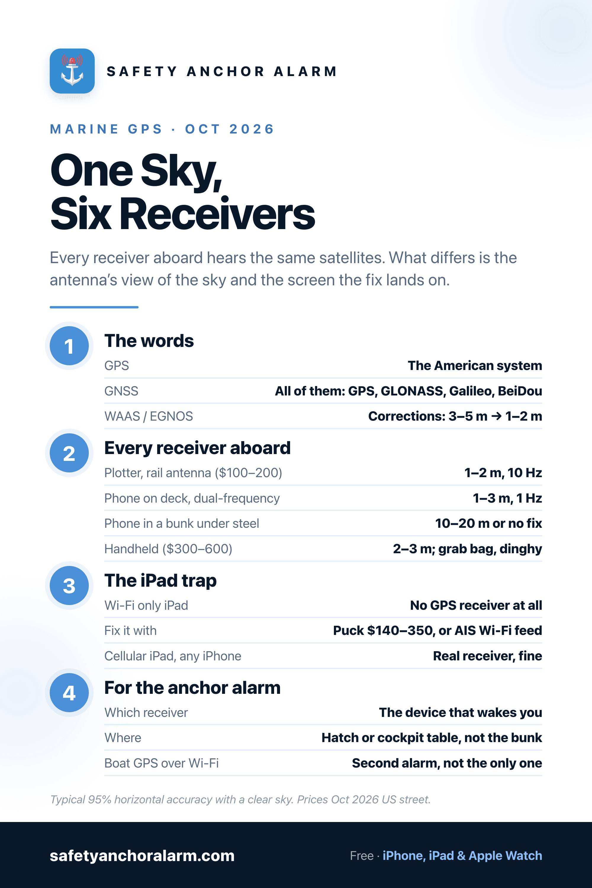
GPS is the American satellite system; GNSS is all of them together (GPS, GLONASS, Galileo, BeiDou), and every receiver aboard uses several. WAAS in North America and EGNOS in Europe broadcast corrections that tighten a 3–5 m fix to 1–2 m; plotters and handhelds apply them, phones mostly do not. A chartplotter with an external antenna on the rail is the best fix aboard (1–2 m, 10 updates a second); a modern phone on deck is 1–5 m once a second, which is the same order of accuracy, and the gap closes to nothing once the phone can see the sky. A Wi-Fi-only iPad has no GPS at all and needs a $140–350 Bluetooth puck or the boat's GPS shared over Wi-Fi; Cellular iPads and all iPhones have a real receiver. A handheld ($300–600) is a grab-bag instrument, not an upgrade. Mount antennas with open sky, not under a metal arch, and check the chart datum is WGS84. For the anchor alarm use the receiver on the device that will wake you, give it sky, and set the radius with the margin the fix needs.
Every Receiver Aboard, Compared
Horizontal accuracy is typical 95 percent figures with a clear sky, from the manufacturers' specifications and published tests; real numbers on the day depend on the sky view more than on the receiver. Prices are October 2026 US street prices.
| Receiver | Accuracy | Updates | Sky view | Cost | Job |
|---|---|---|---|---|---|
| Chartplotter, external antenna (GA 38, RS150, GS25) | 1–2 m with WAAS/EGNOS | 5–10 Hz | Rail or coachroof, full sky | $100–200 antenna | Primary fix for the boat; feeds the network |
| Chartplotter, internal antenna | 1–3 m with WAAS/EGNOS | 5–10 Hz | Under the helm or a hardtop; often partly blocked | Included | Fine on an open console; weak under a metal hardtop |
| AIS transponder's GPS, shared over Wi-Fi | 1–3 m | 1 Hz | Own antenna, usually clear | Included with the AIS | Second fix for tablets and phones aboard |
| Handheld marine GPS (GPSMAP 86, eTrex) | 2–3 m with WAAS | 1 Hz | Wherever it is held | $300–600 | Grab-bag, dinghy, liferaft; inReach models add SOS |
| Phone, dual-frequency (iPhone 14 Pro and later, flagships) | 1–3 m on deck | 1 Hz | Wherever it is lying | Already aboard | Anchor alarm, apps, backup navigation |
| Phone, single-frequency | 3–5 m on deck; 10–20 m below | 1 Hz | Wherever it is lying | Already aboard | Same, with a wider alarm margin |
| iPad Wi-Fi + Cellular | 3–5 m | 1 Hz | Wherever it is lying | Already aboard | Navigation at the chart table |
| iPad Wi-Fi only | None: no receiver | — | — | — | Needs a puck or the boat's GPS over Wi-Fi |
| Bluetooth GPS puck (XGPS160, Bad Elf Pro+, GLO 2) | 2–3 m with WAAS | 10 Hz | Stick it on the dodger | $140–350 | Gives a Wi-Fi iPad a real fix; feeds several devices |
GPS, GNSS and What the Receiver Is Listening To
A satellite navigation receiver does one thing: it times how long a signal took to arrive from each satellite it can hear, and from four or more of those times works out where it is. Every satellite broadcasts its own position and a very precise clock, and the receiver has no clock worth the name, so the fourth satellite is there to solve for time. More satellites in view, spread across the sky rather than bunched overhead, means a better solution. That is the whole reason the number of constellations matters.
| System | Run by | Satellites | Note |
|---|---|---|---|
| GPS | USA | ~31 | The original; L1 since 1995, L5 on newer satellites |
| GLONASS | Russia | ~24 | Second constellation most receivers added |
| Galileo | EU | ~28 | Most accurate civil signal; in every modern phone |
| BeiDou | China | ~45 | Largest constellation; strongest coverage in Asia |
| QZSS / NavIC | Japan / India | 4–7 each | Regional; fill in the sky over East and South Asia |
| WAAS / EGNOS / MSAS / GAGAN | US / EU / Japan / India | 2–4 geostationary each | Not positions: corrections that tighten the fix to 1–2 m |
GPS is the American system and the name everyone uses. GNSS, Global Navigation Satellite System, is the collective term, and since about 2018 every receiver sold for a boat, a phone or a watch has been a GNSS receiver: a phone on deck is typically tracking 25 to 35 satellites across four constellations, where a 2005 plotter had eight or ten from one. The practical gains are a first fix in seconds rather than a minute, and a position that holds when the mast, a cliff or a marina's breakwater blocks a quarter of the sky. When a spec sheet says “GPS/GLONASS/Galileo” that is what it means; when it just says GPS, it almost certainly means the same thing.
WAAS and EGNOS: the Correction Layer
Civilian GPS on its own is good to roughly 3 to 5 metres, with the error coming mostly from the signal's trip through the ionosphere and small errors in the satellites' orbits and clocks. Satellite-based augmentation systems (SBAS) fix most of that: a network of ground stations at known positions measures the error in real time, and geostationary satellites broadcast the corrections on the same frequency as GPS. WAAS covers North America, EGNOS Europe and the Mediterranean, MSAS Japan and GAGAN India; a receiver that applies them gets to about 1 to 2 metres, and they are what the aviation industry built the systems for. Every marine chartplotter and handheld applies SBAS by default and says so in the spec sheet (“WAAS enabled”). Phones, on the whole, do not; they use internet-delivered assistance for a fast fix and their own multi-constellation averaging for accuracy. That is one of the few genuine differences between the plotter and the phone, and it is worth about two metres. Across the Atlantic, out of range of any ground station, SBAS does nothing for anyone.
Dual-Frequency: the Phone Catches Up
The second real difference is newer and runs the other way. The original GPS civilian signal is on one frequency, L1. The modern satellites add L5, a stronger signal that a receiver can compare with L1 to cancel the ionospheric error directly and, more usefully, to reject signals that arrived by bouncing off something. iPhones have had a dual-frequency receiver since the 14 Pro and every iPhone 17 model has one; Android flagships have had it since 2018. In a street between tall buildings it halves the error. On a boat, with water on every side and nothing to reflect from except the rig, the gain is smaller: typically 3 to 5 metres down to 1 to 3. It is why the phone on the cockpit table now matches the plotter more closely than the 2019 advice suggests, and it is not a reason to change phones.
The Plotter: Internal or External Antenna
A chartplotter has a receiver in the box with a small patch antenna under the screen, and most of them do their job on an open console with sky above. Under a metal hardtop, inside a pilothouse, or on a steel or aluminium boat, the patch antenna sees a slice of sky and the fix wanders, drops satellites, or takes minutes to lock. The fix is an external antenna on a rail or the coachroof: a Garmin GA 38, Raymarine RS150, Simrad GS25 or equivalent, $100 to 200, which also puts the position on the NMEA 2000 network for every other instrument to use. The plotter's receiver updates five to ten times a second, which is why its course and speed read steadily at the helm and why a racing boat with a 1 Hz source sees its numbers lag. At anchor the update rate is irrelevant; the antenna's view of the sky is everything.
Mounting rules are short. The antenna wants a clear hemisphere of sky and nothing of its own kind within a metre: not under a radar arch (the radar's metal and its transmissions both interfere), not beside the VHF or AIS antenna, not inside a steel wheelhouse, and not at the masthead where it sweeps through 10 m of arc every roll and the fix reads the boat's motion rather than its position. A stern rail, a coachroof or the top of a dodger frame is the usual answer, and the combo guide's advice about what you are really buying applies here too: the screen is the least important part.
The iPad Question
An iPad sold as Wi-Fi only has no GNSS receiver. It estimates its position from the Wi-Fi networks it can see and from its internet connection, which in a marina with the harbour Wi-Fi in range gives a plausible dot and at anchor gives nothing, or the dot from the last place it had a network. A great many navigators have found this out on the first passage. The Wi-Fi + Cellular iPad has a real receiver and works like a phone; every iPhone does too.
A Wi-Fi iPad gets a fix in one of two ways. A Bluetooth GPS puck, the Dual XGPS160 (about $170), Garmin GLO 2 (about $140) or Bad Elf GPS Pro+ (about $250 to 350), sits on the dodger, applies WAAS, updates ten times a second, runs all day on its battery and feeds several devices at once; the aviation world has used them for years and they are the simplest answer. Or the boat's own GPS is shared over Wi-Fi: most AIS transponders and many plotters broadcast NMEA position data on the boat's Wi-Fi, and iOS navigation apps can read it. That gives the tablet the best antenna aboard and the AIS targets in the same stream, at the price that the tablet is now blind whenever the boat's network is off.
The Handheld
Handheld marine GPS units outlived the prediction that phones would kill them, for reasons that have nothing to do with accuracy. A Garmin GPSMAP 86s (about $400) or 86i with inReach ($500 to 600) floats, is waterproof to IPX7, runs 35 hours on its battery, shows a chart on a screen readable in sun, and has physical buttons that work with wet hands. The 86i and the 67i add Iridium messaging and SOS, which the beacon guide puts in its place. An eTrex 32x (about $300) does the same navigation on AA batteries with no chart to speak of. None of them is a better fix than the plotter or the phone; they are the instrument in the grab bag, the dinghy and the liferaft, and the one a crew member can navigate on when the boat's electrics have gone. Keep it charged, keep a chart loaded, and keep the waypoints for the passage on it.
Datum, COG and the Things GPS Does Not Know
Three small things catch people. First, every GNSS position is on the WGS84 datum, and every modern electronic chart is drawn on it, but an older paper chart or a chart of a remote coast may be on a local datum offset by tens or hundreds of metres; the chart datum note in the margin says which, and the plotter's datum setting must match. In parts of the Pacific and the Caribbean the chart itself was surveyed a century ago and the GPS is more accurate than the coastline it is drawn on, which is why a boat shows up on the beach on the screen while swinging happily in 8 m.
Second, GPS gives course and speed over the ground, from successive positions. It does not know which way the bow points. A sailboat making leeway or a boat in a cross-tide has a COG that differs from its heading by 10 or 20 degrees, which is why the radar overlay and the AIS symbol both want a heading sensor and not just the GPS. Third, speed over ground is not speed through the water; the difference is the current, and the log is the only instrument that measures it.
The Fix the Anchor Alarm Uses
An anchor alarm is the one instrument aboard for which the GPS question is not about accuracy in the abstract but about one night in one place, and the GPS accuracy guide covers the arithmetic: the fix wobbles a few metres, the radius absorbs the wobble, and a drag shows as the position walking in one direction while a wobble stays put. What this guide adds is which receiver to give that job.
The device that wakes you. The plotter has the best antenna and the alarm goes off at the helm; the phone has a lesser antenna and the alarm goes off beside your head. The second is the alarm that gets used, and the anchor alarm on the phone runs on the phone's own battery with the boat's instruments off. So the practical question is how to give the phone the sky, and the answer is to stop keeping it in the bunk. A phone on the chart table under an open hatch, in the companionway, or on the cockpit table under the dodger sees most of the sky and holds 3 to 5 metres; the same phone in a quarter berth under a steel deck sees a sliver and can read 20 metres or lose the fix. Two metres of accuracy is not what moves the alarm; thirty centimetres of deck is.
The boat's GPS as a second source. A phone or tablet reading the AIS or plotter position over Wi-Fi gets the rail antenna's fix, which is the best aboard, and a navigation app with an anchor alarm can run on it. The cost is a dependency: the alarm now needs the boat's Wi-Fi, the AIS and the house bank to stay up all night, and a breaker tripping at 02:00 silences it without a sound. Run it as the second alarm, not instead of the phone's own receiver. The dragging guide covers what to do when either one goes off.
The Bottom Line
GPS is the American system, GNSS is all of them, and every receiver aboard listens to several. WAAS and EGNOS tighten the fix by about two metres and the plotter applies them; dual frequency gives the phone most of that back. What actually separates the receivers aboard is the antenna's view of the sky and the screen the fix lands on. Give the plotter an external antenna if it lives under metal, give a Wi-Fi iPad a puck or the boat's Wi-Fi feed, keep a charged handheld in the grab bag, check the datum, and for the anchor alarm use the phone that will wake you, put it where it can see sky, and let the radius carry the margin.

Safety Anchor Alarm
The plotter has the better antenna. The phone has the alarm that goes off beside your head. Give the phone a view of the sky and let it do the night watch on its own battery.
Download Free